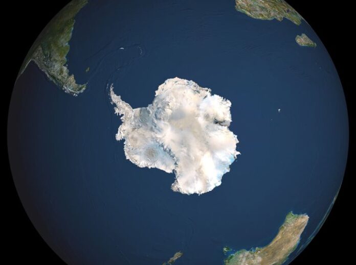
Antarctica from space often leads to stunning visuals that capture the imagination. However, it’s crucial to understand the difference between actual photographs and computer-generated visualizations when exploring this topic.
Antarctica From Space: Separating Fact from Fiction
The concept of viewing Antarctica from space has captivated people’s attention, but not all images circulating online are what they seem. A widely shared image purporting to show Antarctica from space is actually a computer-generated visualization created by NASA using data from its Terra and Aqua satellites. This visualization depicts sea ice conditions around Antarctica on September 21, 2005, combining data from multiple sources to create a photorealistic representation of the continent.
While this image is not a direct photograph, it is based on real scientific data and serves an important purpose in helping scientists and the public understand Antarctic ice conditions. The visualization was created using sea ice data from the AMSR-E microwave radiometer on NASA’s Aqua satellite, with terrain and cloud cover data derived from visual interpretations of Earth generated using data from MODIS instruments on Terra and Aqua satellites.
The Science Behind Satellite Imagery of Antarctica
Satellites play a crucial role in monitoring and studying Antarctica from space. Various instruments and techniques are used to gather data and create images of the continent:
Microwave Radiometry:Instruments like AMSR-E use microwaves to measure the extent of ice floating in the ocean. This technology allows scientists to track changes in sea ice coverage over time.
Visual and Infrared Imaging: Instruments such as MODIS capture visual and infrared data, which can be used to create detailed images of the Antarctic landscape and cloud cover.
Radar Technology: Some satellites use radar to penetrate cloud cover and provide detailed images of the ice surface, even in areas often obscured by weather.
Real Photographs vs. Data Visualizations
It’s important to distinguish between actual photographs taken from space and data visualizations:
Actual Photographs
These are direct images captured by cameras on satellites or spacecraft. While NASA and other space agencies do have real photographs of Antarctica from space, they may not always provide the comprehensive view that visualizations can offer.
Data Visualizations
These are computer-generated images created by combining data from various sources. The widely shared “Antarctica from space” image falls into this category. While not a direct photograph, it accurately represents scientific data in a visually appealing format.
The Importance of Antarctic Satellite Observations
Satellite observations of Antarctica are crucial for several reasons:
- Monitoring Ice Coverage: Satellites allow scientists to track changes in sea ice extent and land ice volume over time, which is essential for understanding climate change impacts.
- Weather Forecasting:Satellite data helps meteorologists predict weather patterns in and around Antarctica, which is crucial for both scientific expeditions and global climate models.
- Studying Ecosystem Changes: Observations from space can reveal changes in Antarctic ecosystems, such as shifts in penguin colony locations or alterations in marine habitats.
- Geological Research: Satellite imagery assists in mapping and studying Antarctic geology, including identifying potential sites for scientific drilling projects.
Challenges in Imaging Antarctica from Space
Capturing clear images of Antarctica from space presents several challenges:
- Cloud Cover:Antarctica is often obscured by clouds, making it difficult to obtain clear visual images of the surface.
- Extreme Light Conditions:Long periods of darkness during winter and constant daylight during summer can complicate imaging.
- Vast Size: Antarctica’s enormous size requires multiple satellite passes or composite images to capture the entire continent.
Scientific Missions Studying Antarctica from Space
Several scientific missions have contributed to our understanding of Antarctica from space:
CREAM (Cosmic-Ray Energetics And Mass):Â
While not directly imaging Antarctica, this balloon-borne experiment launched from Antarctica has provided valuable data on cosmic rays, showcasing the continent’s importance as a scientific research platform.
GRACE (Gravity Recovery and Climate Experiment):Â
This mission uses satellite measurements to track changes in Antarctic ice mass, providing crucial data on ice loss and sea level rise.
The Future of Antarctic Observation from Space
As technology advances, our ability to observe and understand Antarctica from space continues to improve. Future missions and technologies may include:
- Higher resolution imaging capabilities
- More frequent satellite passes for near-real-time monitoring
- Advanced radar and lidar systems for better ice thickness measurements
- Improved data processing techniques for more accurate visualizations
Final Words
While the widely shared image of “Antarctica from space” may not be a direct photograph, it represents an important tool in scientific visualization and public understanding of the continent. As we continue to study Antarctica from space, it’s crucial to appreciate both the beauty and scientific value of these images, whether they are direct photographs or data visualizations. By combining various satellite technologies and data sources, scientists can create a comprehensive picture of Antarctica’s changing landscape, contributing to our understanding of global climate systems and the unique ecosystems of this remote continent.
Read More: The Saga of Sahara Desert Rose


